Fossil Fuels
The fossil fuel industry faces significant challenges, such as regulatory compliance, transportation logistics, environmental stewardship, and technology changes. JMT understands these challenges are ever changing and cannot always be anticipated; therefore, we have a dedicated team of dynamic, highly qualified individuals to meet the needs of the fossil fuel industry that can react at a moment’s notice. JMT has a dedicated team to provide services from land acquisition through environmental compliance to design and commissioning.
Fueling Progress: JMT’s Comprehensive Role in the Adelphia Gateway Natural Gas Pipeline Project
JMT supported the engineering, permitting, and compliance for a large natural gas pipeline project.
Location: Southeast, PA
Client: Adelphia Gateway, LLC
The Adelphia Gateway Project was a significant natural gas infrastructure project to supply low cost natural to millions of homes, businesses, and industries. The project scope included a repurposed 84-mile natural gas pipeline, construction of five new miles of pipeline, two compressor stations and miscellaneous facilities. JMT’s project scope involved various disciplines including Survey, Geotechnical sampling, testing and engineering, Permitting (Municipal and Penn DOT), Water Resources to develop storm water management and individual erosion and sedimentation control plans, Construction plans, SUE (underground utility locates), traffic control plans including Highway Occupancy Permits, and maintenance & Protection of traffic, structural foundation design. Another large focus of the project was the DEP required ESCGP-3 environmental permitting which involved the evaluation of final construction development and analyzing for additional; post construction storm water management.
Navigating the Terrain: Master Pipeline Planning & Design in North Carolina
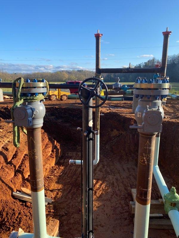
Engineering and field services support for the evaluation, design and construction of a new 38 mile natural gas pipeline.
Location: Rutherford & McDowell Counties, North Carolina
Client: Dominion Energy
JMT provided master pipeline planning and design services for Dominion Energy on the M-64 pipeline project. The team at JMT provided the routing, permitting, surveying, design, land acquisition, pipeline staking, easement staking, land agent services, and as-built surveying for approximately 36 linear miles of natural gas pipeline and 2 miles of natural gas distribution main. The pipeline consists of 12-inch-coated steel, and the distribution main consists of eight-inch medium density polyethylene (MDPE). JMT provided a diverse range of surveying services from the beginning of the project to the end. Our land agents contacted the property owners and obtained right-of-entry for our fieldwork to begin in lieu of waiting the 30 Days. JMT designed the final route(s), preparation of construction plans, traffic control plans, and erosion control plans and specifications, as well as preparation and submission of required permit drawings. The final plans included plan view of route and elevation profile showing road, utility, property stream and other crossings. JMT incorporated by reference designs and specifications provided by Dominion
Delivering Infrastructure: JMT environmental planning and oversight
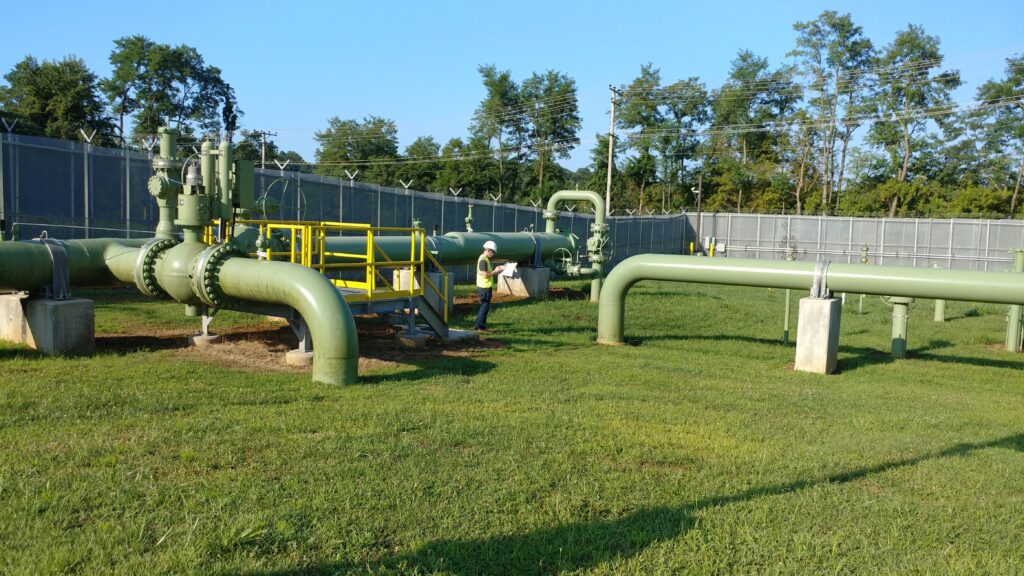
Engineering and field services support for the evaluation, design and construction of a new and existing natural gas infrastructure.
Location: Maryland, Pennsylvania, Virginia
Client: Energy Client
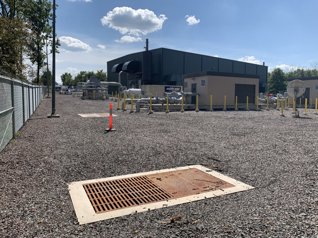
In the energy industry, asset integrity is key. Understanding the condition of the service infrastructure is very important. One of the larger oil and gas operators has a robust program of identification of asset integrity and repairs. For this client, JMT is the environmental consulting firm of choice performing various environmental design, permitting, and field inspection tasks in Maryland, Pennsylvania, and Virginia.
Project assignments have included maintenance and repair of station rebuilds, pipeline relocations and replacements, cathodic protection upgrades, corrosion mitigation, and construction and post-construction environmental inspection.
JMT’s valuable experience navigating the complicated county and state permitting systems in the mid-Atlantic states saves the client time and money by obtaining permits on schedule and within budget. Our environmental scientists represent the client as subject matter experts at various project meetings.
JMT provides environmental permitting guidance to our client’s project teams, helping them make informed decisions with a thorough understanding of the permitting schedule implications.
Revolutionizing Oil and Gas Permitting in Ohio: JMT’s Web-Based RICS Platform for ODNR
JMT provided web-based design support services to aid in revolutionizing oil and gas permitting in Ohio with RICS.
Location: Ohio
Client: Ohio Department of Natural Resources
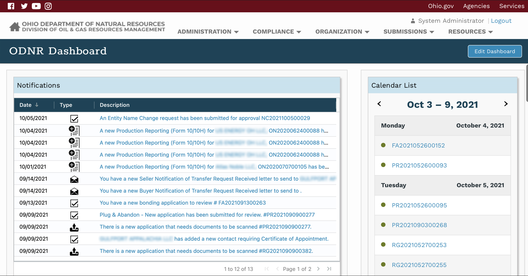
The Ohio Department of Natural Resources (ODNR) has taken a significant step forward by replacing its outdated risk-based data management system (RBDMS) with the innovative RICS platform. This web-based system is designed to streamline activities, allow customers to request permits, and provide the public with vital information about oil and gas activities in Ohio. RICS supports ODNR’s registration, financial assurance, and permitting activities by enabling the department to define workflows, build pages, and deploy these workflows seamlessly. For example, approved entities can now submit a permit application to drill an oil and gas well through a step-by-step guided process. This process ensures compliance with applicable rules and laws, allows users to pay fees online, and routes the application to the appropriate ODNR staff for a multi-level review and approval process.
In addition to the core workflow functionality, RICS includes various components such as contacts, notes, approval tasks, emailing, mailing, and payment processing tools. These features facilitate multi-level reviews of data submissions, auditing, note sharing, and tracking the status of submissions within the workflow. JMT has tailored RICS to meet the specific needs of the oil and gas industry. For instance, the permitting workflow guides users through designing a well casing plan using GIS technology. This technology queries relevant data to determine the appropriate rules and regulations based on the well’s location, considering factors like underground drinking water, mines, and other geological features. The application dynamically generates a well diagram for applicants and reviewers.
Mapping Success: Revolutionizing Utility Coordination in Pennsylvania with JMT’s Innovative Solution
Streamlining Utility and Public Works Projects with JMT’s Utility Coordination Solution
Location: Pennsylvania
Client: Pennsylvania One Call System
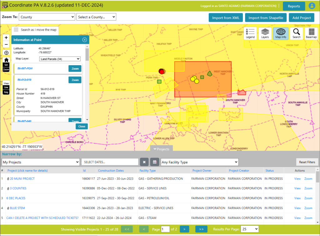
JMT’s Utility Coordination Solution is a powerful tool designed for utility and public works project planning and coordination. It offers a spatial, map-based view of underground utility and public works projects, helping to identify opportunities for coordination and collaboration when projects overlap in space and time. All information is kept in one place, with notifications, approvals, and documentation time-stamped and readily available for review if needed. This makes it easy to track the progress and history of a project.
One of the standout features of this solution is its user-friendly mapping. Users can easily pinpoint the footprint of their project without needing technical information. If you can find the location on a map, you can capture it in JMT’s Utility Coordination Solution. This simple, intuitive mapping allows users to identify work areas and phases with ease. The system also includes system-generated messaging and approvals. Once the project area is identified, the tool automatically generates notifications to the appropriate stakeholders, whether the project crosses county, township, or city lines. This ensures that all relevant parties are informed and can coordinate effectively.
Security is a key consideration in the design of this tool. While sharing information is crucial for coordination, it can sometimes give away a competitive advantage. To address this, the tool keeps shared information private for the user while notifying the appropriate stakeholders for approvals. This balance ensures that sensitive information is protected while still facilitating necessary communication.
JMT’s GIS and Technology Services: A Game Changer
JMT has provided engineering, GIS, and technology services support to PARSA.
Location: New Jersey
Client: Plainfield Area Regional Sewerage Authority (PARSA)
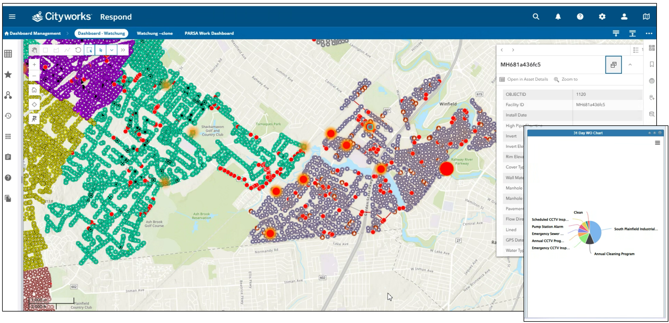
PARSA operates a regional interceptor system that serves a population of approximately 135,000 spreads among eight municipalities and three counties. The interceptor system comprises approximately 25 miles of pipe ranging in size from 10” to 54” in diameter. PARSA’s services have since expanded, and it is now providing licensed operation to some of the member municipalities.
JMT helped expand the footprint of their GIS dataset over new municipalities and improved asset symbology for easier use in the field. As part of that growth, any newly created GIS layers were integrated into Cityworks and configured for work order creation. JMT helped troubleshoot existing and new Cityworks configurations. JMT further assisted in streamlining the data collection user experience and transferred over 5,000 images from Trimble Unity to PARSA’s preferred GIS data collection application, Field Maps. JMT also supported PARSA by building smart forms with automated calculations and by providing training to staff. Finally, dashboards were created to track progress and visualize data quality on data collection tasks.
As a result of this project, the client gained a more streamlined data collection set of tools customized to their needs, as well as ongoing training, support, and troubleshooting throughout the change period. By providing a team composed of a GIS analyst and a water waste water expert, PARSA benefited from a multidisciplinary and informed approach for their data collection methodology improvements.
Innovative Utility Mapping: JMT’s High-Tech Solutions for Amtrak’s Northeast Corridor
JMT has provided technology services support to Amtrak.
Location: Trenton, New Jersey
Client: Amtrak
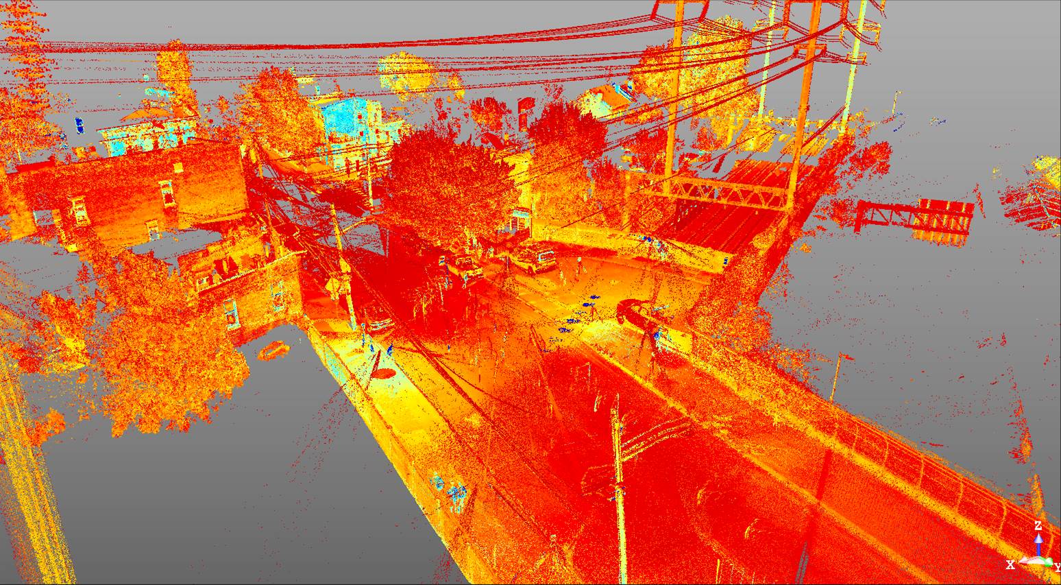
This project was completed with High Definition (HD) Terrestrial Laser Scanner (TLS) for The Amtrak line is the main Northeast Corridor in Trenton NJ. With the Amtrak schedule, this section of the corridor would need to be shutdown, with flagmen, and NJDOT closures in order to survey with traditional methods. Closing this would alter the entire schedule of Amtrak from Washington DC to Connecticut, so it was not even a consideration. The TLS allowed JMT field crews to quickly captured detailed information from any visible point cloud data collected in order to create a survey base map. For the NJ Wind Port we had the entire site flown using LiDAR utilizing commercial aircraft and UAS devices. Also, the Terrestrial Laser Scanner was used to capture wire heights and elevations to better document and validate the transmission line clearances.
Revolutionizing Construction: JMT’s vSite AR Platform Enhances Safety and Efficiency
JMT Technology Group implemented vSite, an augmented reality platform that overlays digital models of underground utilities onto real-world views.
Client: JMT
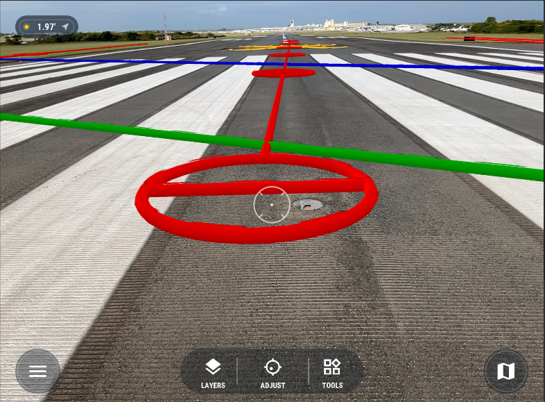
By integrating with LiDAR scanning technology, vSite provides precise documentation, minimizes utility strike risks, and improves project efficiency. It seamlessly integrates with CAD and GIS data, allowing field users to visualize underground utilities on devices like iPads. This innovative approach enhances safety, reduces costs, and streamlines workflows, positioning JMT Technology Group as a leader in advanced construction technology.
Recently, JMT tested vSite on a runway upgrade project and a water main replacement project in Petersburg, VA. The AR tools on iPads displayed utility layers, aiding excavation and visualizing the entire length of utilities.
JMT also modernized as-built workflows through reality capture. LiDAR scans collected with iOS devices and GNSS/GPS are processed into design applications, updating as-built drawings in real-world coordinates. These scans provide spatial references for calculating length, area, and volume, useful for project claims.
Fossil Fuels